NEWS
Two dead after 6.4 magnitude California quake leaves 70,000 without power

Eleven people were reportedly injured and assessment of total number is ongoing, said officials
A magnitude 6.4 earthquake shook parts of northern early Tuesday, jolting people awake, damaging buildings and roads and leaving tens of thousands without power.
to the quake “as a result of medical emergencies occurring during and/or just following” the incident, the Humboldt county sheriff’s office reported Tuesday afternoon.
Centered just south-west of the town of Ferndale in Humboldt county, a small community near the coast about 213 miles (343km) north-west of San Francisco, the quake took place in area where tremors aren’t uncommon. But locals called it the largest in recent memory.
“It was probably the most violent earthquake we have felt in the 15 years I have lived here,” Eureka resident Dan Dixon, 40, said. “It physically moved our bed.” But, he added, his infant had slept through it.
Just after 2.30am local time, phones across the region buzzed to life warning residents of the rattling to come. Moments later, concrete ruptured, water pipes burst and picture frames were thrown from the walls.
The state’s warning system alerted roughly 3 million people across the region, according to california governor’s office of emergency services, giving them at least 10 seconds to take cover.
Wow. This is the aftermath of a strong magnitude 6.4 earthquake that rocked Northern California this morning.
Caroline Titus shared the video of their 140-year-old Victorian home. She writes: “This was our coffee station. Sorry for dark video. Power still out.”pic.
The shaking could be felt across, from south of San Jose, California, into Oregon to the north, according to surveys collected by the United States Geological Survey. There were 80 strong aftershocks that also jolted the region following the quake, some as powerful as 4.6 magnitude, according to Cal OES, and more are expected. There’s a 13% chance of an aftershock larger than 5 magnitude over the next week, but the probability is constantly shifting, said USGS officials Tuesday at a news conference.
Eleven people were reported as injured and Cal OES director Mark Ghilarducci said officials are still assessing the total numbers of injuries.
Risks that remain, as aftershocks could further rattle damaged and vulnerable infrastructure. But nonstructural elements – plates, bookshelves and TVs not anchored – are most dangerous.
“The potential for having a bookshelf come over and injure you is high,” he said, cautioning locals to remove hazards or steer clear of them.
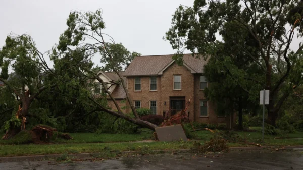
Footage posted on social media showcased the seismic damage, as locals emerged to assess the mess left behind. Household items were strewn across the floor, backyards were filled with debris, and glass from storefront windows shattered across sidewalks. The historic Ferndale bridge, which crosses the Eel River, was cracked and the shaking also felled power lines and spouted gas leaks, causing one building to erupt in flames. The fire was quickly extinguished.
FERNBRIDGE EARTHQUAKE DAMAGE: Damage to Fernbridge following the 6.2 magnitude in Humboldt County. Main road to Ferndale currently closed off by CalTrans as crews inspect for additional damage.
Caroline Titus, a resident of Ferndale, tweeted video in her darkened home of toppled furniture and smashed dishes. “Our home is a 140-year-old Victorian. The north/south shaking is very evident in what fell,” she tweeted. “That was a big one,” she said in another tweet.
After the earthquake, more than 70,000 customers were reported to be without power in the surrounding area, according to power which tracks outages across the country – nearly 75% of people across the area. Two hospitals in the area also lost power and are running on generators.
With a surge in winter weather settling in across the area over the coming days, there are also concerns that displaced people will face increased exposure to the cold. Local and state emergency response teams are working with the National Weather Service and the American Red Cross to prepare, Ghilarducci said, and amplifying efforts to secure access to shelter.
Damage assessments are ongoing and expected to continue for days as engineers and contractors examine impacted foundations, roadways, and homes. But so far, the damage seems to be less than what might be expected from the size of the temblor, according to Brian Ferguson, a spokesperson for the Cal OES.
Scientists have also been deployed into the field to study the damage and features of the quake, said Cynthia Pridmore, a senior engineering geologist for the USGS.
The county of 136,000 residents is in a region of the state that has a long history of large earthquakes, including a magnitude 7.0 in 1980 and a 6.8 in 2014, according to the California Earthquake Authority. Pridmore added that there have been more than 40 large earthquakes in the area over the last century.
“Earthquakes are common in the region around the Mendocino triple junction,” the USGS posted on an informational page about the event, noting a 6.2 magnitude quake that occurred just 20km south-west exactly one year ago. “In the past century, there have been at least 40 other earthquakes of M6 or larger,” they said, “including six earthquakes M7 or larger, within 250 km of the December 20, 2022 earthquake.”
The earthquake also came just days after a small magnitude 3.6 earthquake struck the San Francisco Bay Area, waking up thousands of people at 3.39am Saturday and causing minor damage. That earthquake was centered in El Cerrito, about a 16-mile (25km) drive to downtown San Francisco.
Scientists have, for years, been warning that “the big one” – a catastrophic earthquake rivaling any that’s been experienced so far – is due in California. But they are difficult to predict. Officials have cautioned the importance of being prepared for the event, and smaller ones like this quake.
“We live in earthquake country and this is another example that an earthquake can occur at any time without notice,” Ghilarducci said, noting the importance of having a plan in place. When the power and key infrastructure goes out, having a store of shelf-stable food and plenty of water is essential. He also encouraged more people to download the state’s My Shake App, which worked to give many who were impacted more moments to drop, cover and hold.
“We have seen on numerous occasions that the early warning system is a very valuable tool,” he said. “It is something you can have and be able to have another tool in the toolbox to make your family as safe as possible.”

NEWS
Almost two-thirds of elephant habitat lost across Asia, study finds

Elephants have lost almost two-thirds of their habitat across Asia, the result of hundreds of years of deforestation and increasing human use of land for agriculture and infrastructure, a new study has found.
The Asian elephant, listed as endangered, is found across 13 countries in the continent but their forest and grassland habitats have been eroded by more than 64% – equating to 3.3 million square kilometers of land – since the year 1700, researchers said.
The study, published Thursday in the journal Scientific Reports, compiles the work of several experts led by biologist and conservation scientist Shermin de Silva, a professor from the University of California, San Diego.
The team found that large-scale habitat loss has driven up the potential for conflict between elephants and humans – a situation that shouldn’t be accepted as inevitable and one that can be avoided with proper planning.
“My worry is that we are going to reach a tipping point in which cultures of mutual non-confrontation toward one another get replaced by cultures of antagonism and violence – by both species … We have to de-escalate this situation,” said de Silva, who is also founder and president of Trunks and Leaves a non-profit dedicated to the conservation of wild Asian elephants and their habitats.
The study found that the greatest decline in elephant habitats was in China, where 94% of suitable land was lost between 1700 and 2015. That was followed by India, which lost 86%.
Meanwhile, more than half of suitable elephant habitats have been lost in Bangladesh, Thailand, Vietnam and Indonesia’s Sumatra. Bhutan, Nepal and Sri Lanka also saw a significant decline – mostly in areas where elephants still roam today.
“Restoring these habitats doesn’t necessarily mean keeping them static. Instead we need to better understand the role of people (rural agriculturalists, indigenous communities) who are often marginalized in the economic systems that have been put in place,” de Silva said.
“We also need to reckon with how these dynamics can be maintained sustainably, given the current and future human population size as well as climate change.”
Colonization sped up the loss of habitat
Researchers found there was an acceleration in elephant habitat loss from the year 1700, which coincided with the expansion of European colonization of the region.
During this time, logging, road-building, resource extraction and deforestation ramped up, and farming became more intense on land that might otherwise have hosted wildlife.
The era also saw “new value systems, market forces, and governance policies” reaching beyond the cities of Europe into the forests of Asia – speeding up elephant habitat loss and the fragmentation of the species, the study found.
“In the year 1700 an elephant might hypothetically have been able to traverse as much as 45% of the ‘suitable’ area without interruption, but by 2015 this was down to just 7.5%,” the authors said.
India and Sri Lanka have the largest remaining wild population of elephants in South Asia.
Both countries were “transformed” by colonial-era road-building and logging “during which elephants and other wildlife were eradicated from higher elevations and lowland rainforests, which were converted to plantations and settlements,” the researchers said.
De Silva said the industrial revolution was followed by “a second wave” in the middle of the last century that drove greater habitat loss.
“We observed that in some places, like Thailand and China, the major losses occur following the 1950s. The colonial era had already introduced large-scale plantations in South Asia, but these later changes came from large-scale agriculture,” she said.
Today, humans are expanding further into wild spaces with population centers, agriculture, and extractive industries like mining.
And elephants are increasingly coming into conflict with humans.
Encounters between elephants and humans
In India’s eastern state of Assam, conflict with elephants dramatically increased in the 1980s, corresponding with a drop in forest cover below 30% to 40% of the landscape, the study said.
Political and social issues have also played a part.
During the Rohingya crisis in 2017, thousands of minority Muslim Rohingya people from Myanmar arrived in neighboring Bangladesh, fleeing a violent military campaign. About 1 million people are now living in the world’s biggest refugee camp in Cox’s Bazar – in an area that was once the forest home to an elephant population.
NEWS
How an underwater film inspired a marine protected area off Kenya’s coast

Famous for its sprawling nature reserves that are home to all “Big Five” animals, Kenya’s 882 miles of coastline along the Indian Ocean are often overlooked. It’s a place where people go to “chill out,” but not to observe and connect with the wild and unique ecosystem, says Kenyan filmmaker, photographer and conservationist Jahawi Bertolli.
Bertolli is determined to change this outlook and believes that visual storytelling is one way to do it. “No one was telling stories about the ocean here (in Kenya),” he says.
So far, his work has focused mainly on the Lamu Archipelago along Kenya’s northern coast, where his wife Elke Bertolli, also a photographer and filmmaker, grew up. Lamu is a hidden gem, he says, and filming has led to new discoveries. “There’s not much scientific work that’s happened up here so a lot of what we’re finding is new,” he adds. “We’re finding these incredible reefs. We’re finding incredible biodiversity.”
But this rich biodiversity is increasingly under threat. Bertolli says that harmful fishing practices, such as drag netting, coupled with habitat degradation due, in part, to coastal development, pollution and an increasing human population have caused a reduction in fish populations.
Related: Stunning images from African Wildlife Foundation’s photography award are inspiring conservation
Not only is this bad for the ecosystem, but for local fishers too. Lamu is home to one of the oldest Swahili settlements in East Africa, a community who have depended on the ocean since the 12th century. Traditionally these fishers respected the balance with nature, says Bertolli. They stopped fishing when they had enough for what was needed, they only fished in certain seasons, and they left the coral reef alone, understanding it to be a home for fish, where they needed space and time to reproduce and grow. “There’s a lot of cultural knowledge, which is actually conservation knowledge. It’s just packaged differently,” Bertolli explains.
“A powerful tool”
In 2020, Bertolli made a short film about Lamu’s sea life and the conservation traditions of the local fishers. He called it “Bahari Yetu” – “Our Ocean” in Swahili – and began showing it the local community. The screenings were a gamechanger, he says: “When you bring back that imagery, all of a sudden people are like, ‘Oh my God. Wow, this is ours … this is our heritage, these are our reefs, this is what’s happening underwater in our ocean.’”
A viewing of “Bahari Yetu” was also put on for local beach management units and members from the county government and fisheries department. Bertolli also screened another film he had made a few years earlier on locally managed marine areas in Africa. The next time the group met, all members voted unanimously to begin setting up a marine protected area around Lamu’s Kinyika island, a craggy rock that acts as a nursing ground for seafaring birds and hosts a bustling coral reef system.
For Bertolli and the people of the Lamu Archipelago, this has been a significant first step to ensuring the preservation of an essential ecosystem. While it’s only the beginning and a management plan still needs to be established, Bertolli believes it has also been a testament to the power of visual storytelling. “Because it was their film, told in their language, filmed here – it became an incredibly powerful tool to inspire the community to come together to try and start actually conserving these areas,” he says.
NEWS
Starship could be ready to launch again in ‘six to eight weeks,’ Elon Musk sa

Since SpaceX’s inaugural test flight of the most powerful rocket ever constructed, the company’s engineers, federal regulators and environmentalists have been trying to assess the aftermath of the spacecraft’s explosion and what happens next.
“The outcome was roughly in (line) with what I expected and, maybe slightly exceeded my expectations,” SpaceX CEO Elon Musk said during a Twitter Spaces chat on Saturday evening.
The April 20 liftoff of Starship, as the vehicle is called, was tremendously powerful, causing some damage to SpaceX’s launchpad in South Texas.
Musk said he was “glad to report that the pad damage is actually quite small,” though it would take “six to eight weeks” to get the infrastructure prepared for another launch. He later added that when the rocket’s engines — 30 out of 33 of which fired on for the flight test — reached “full thrust,” it “probably shattered the concrete.”
The explosion in midair also prompted a federal investigation that could take weeks or months to complete.
In the test mission, SpaceX’s Starship launched toward space atop a Super Heavy rocket booster.
Minutes after liftoff, the spacecraft was expected to separate from the rocket booster, but the Super Heavy “vehicle experienced multiple engines out during the flight test, lost altitude, and began to tumble,” according to SpaceX.
The company described what happened as a “rapid unscheduled disassembly” — its oft-used euphemism for an explosive mishap.
The vehicle’s flight termination, or self-destruct, feature was triggered, exploding the spacecraft and booster over the Gulf of Mexico. Musk said that feature took longer than expected to blow up the rocket, ensuring it didn’t careen off course, and that the flight termination system would need to be re-certified. That could be the determining factor in how long it takes the company to get a new Starship on the launch pad.
But there was some good news: “The vehicle structural margins appear to be better than we expected,” Musk said. “As we can tell the vehicle is actually doing somersaults towards the end and still staying intact.”
Here’s what the Federal Aviation Administration, NASA and other agencies have had to say since then.
The FAA
The FAA is charged with overseeing the mishap investigation. The agency licenses commercial rocket launches and gave the green light for the launch attempt after more than a year of back-and-forth.
Such investigations are routine and have taken place after previous — but smaller-scale — Starship test launches in South Texas.
The FAA’s review “will determine the root cause of the event and identify corrective actions the operator must implement to avoid a recurrence,” the agency said in an emailed statement Friday.
eculate on timelines,” the FAA said. “Safety will dictate the timeline.”
Cameron County, Texas, which encompasses SpaceX’s facilities near Boca Chica Beach, the city of Brownsville, as well as South Padre Island and Port Isabel — alerted the public to contact SpaceX if any debris is found.
“If you believe you have found a piece of debris, please do not attempt to handle or retrieve the debris directly,” a notice on Cameron County’s website reads.
A hotline to report debris has been set up at 866-623-0234, or officials can be reached by email at recovery@spacex.com.
The US Fish and Wildlife Service
The US Fish and Wildlife Service said in a statement that it’s working with SpaceX, the FAA and other involved parties to “provide on-the-ground guidance to minimize further impacts and reduce long-term damages to natural resources.
That activity includes ensuring that SpaceX is complying with the Endangered Species Act — which became the subject of concern after reports that debris from the launch or explosion may have reached nearby protected wildlife areas.
“Following the launch and mid-air explosion, Cameron County closed Boca Chica Beach and State Highway 4 for 48 hours due to launch pad safety concerns, which prevented Service staff from accessing refuge-owned and managed land,” the agency’s statement reads. “Once the closure ended, Service staff began their assessment of the launch impacts at 10 a.m. April
-
INTERNATIONAL10 months ago
Latvia, Estonia leave China-backed East Europe forum – wrde.com
-
POLITICS1 year ago
New York Times wants its reporters to spend less time on Twitter – New York Post
-
BUSINESS1 year ago
Camara de Comercio Empresarial launches its first NFT-PUG BUSINESS collection
-
ESPAÑOL1 year ago
Conoce a Rueda Empire, el exitoso productor Musical
-
NEWS10 months ago
Jaime Lee: 2 Girls 1 Blunt
-
U.S.1 year ago
A Proclamation on Law Day, USA, 2022 – The White House
-
MIAMI1 year ago
Pop singer Van Hechter and super producer Villagomez team up to create a brand new summer anthem ”Love In Miami”!
-
U.S.12 months ago
Sis Wins Gold Medal With USA Volleyball at Pan American Cup – GoCreighton.com